![]()
 Up and out and on the road by 9:50. It's getting
hot. I head west on Rt. 19, towards Mabou. This will let me do the
Cabot trail in a clockwise direction. My dad said to do it that way, so
that you won't be in the lane next to the cliff edges during the trip. The
motorcycle tour guide also gives the same advice. Looking at the map,
and chatting with people, I have a third reason to do it - there should be less
traffic.
Up and out and on the road by 9:50. It's getting
hot. I head west on Rt. 19, towards Mabou. This will let me do the
Cabot trail in a clockwise direction. My dad said to do it that way, so
that you won't be in the lane next to the cliff edges during the trip. The
motorcycle tour guide also gives the same advice. Looking at the map,
and chatting with people, I have a third reason to do it - there should be less
traffic.
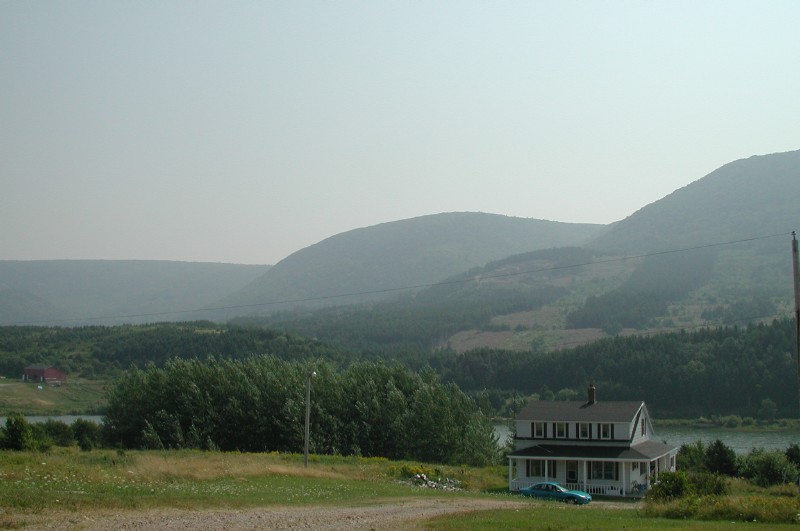
Rt. 19 travels along the west side of Cape Breton, going north. It's basically fishing villages, along the lines of those on the eastern shore of New Brunswick. Which is not too surprising, since both face the Gulf of St. Lawrence. In fact, around Cheticamp, there is a large Acadian population.
Rt. 19 is mostly good, with some rough patches. (This just basically applies across the board to N.S.) At Maragee forks, 19 joins the Cabot Trail. After another 30 minutes or so, we enter the Cape Breton Highlands National Park. I think 30 minutes, but the road and weather and scenery had put me into a reverie, and I have lost track of some time.
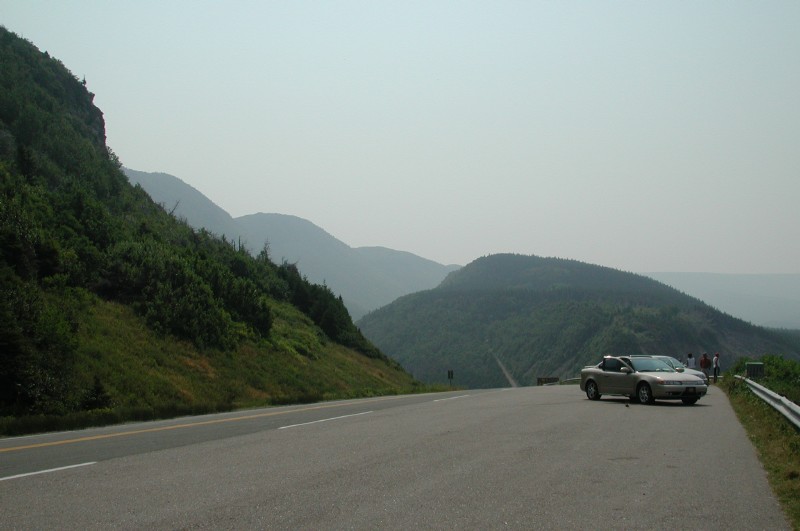 Anyway, into the park, (which no guide mentioned costs
money. It costs me $3.50. No biggie, but I had to pull over to do it.) and
around the first couple of corners I find this sight. May I say, it's stunningly
beautiful? Breathtaking? Majestic? Etc? Consider it said. Also, the
Parks system has put in lots of wonderfully placed Scenic Lookouts (Lookout!).
The road is better than it had been up till now, lots of passing lanes.
And it's now about 12:00, so many people are pulling over for lunch. Ha.
Anyway, into the park, (which no guide mentioned costs
money. It costs me $3.50. No biggie, but I had to pull over to do it.) and
around the first couple of corners I find this sight. May I say, it's stunningly
beautiful? Breathtaking? Majestic? Etc? Consider it said. Also, the
Parks system has put in lots of wonderfully placed Scenic Lookouts (Lookout!).
The road is better than it had been up till now, lots of passing lanes.
And it's now about 12:00, so many people are pulling over for lunch. Ha.
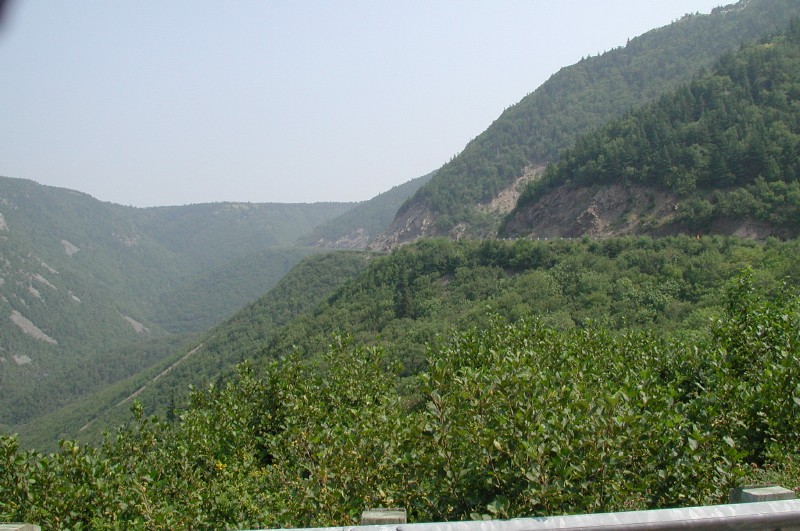 Around another corner later on, we have this view of the road
upcoming. Oh, yeah, baby. This is what the trip is all about.
Excellent roads, in excellent scenery. Too bad about the heat. Have
I mentioned it's very hot? It is. I make several stops for pictures along
the west coast.
Around another corner later on, we have this view of the road
upcoming. Oh, yeah, baby. This is what the trip is all about.
Excellent roads, in excellent scenery. Too bad about the heat. Have
I mentioned it's very hot? It is. I make several stops for pictures along
the west coast.
The Cabot Trail exits the park, and turns east, through small villages like Pleasant Bay. It must be a very different life out here, a long, long way from anywhere on a sometimes patchy road. Yep. about the time I started thinking what a great-surfaced road it was, I hit an area of painful ripples. That happened several times. "Mmmm, smooth. Ow. Rough. Mmmm. Smooth." And so on.
The road climbs and drops over several mountains, ascending and descending in a series of 30Kmh switchbacks. So far today, I have only passed about 8 or 10 vehicles. This is going great.
In Cape North, the northern-most paved road in Nova Scotia, I stop to get gas. I water up, and evidence is that I am properly hydrated. It is hot. I remember to apply sun block.
The Cabot Trail turns south, and leads back into the park. With the sun in the west, the high trees and hills throw a little shade on the road. I revel in it.
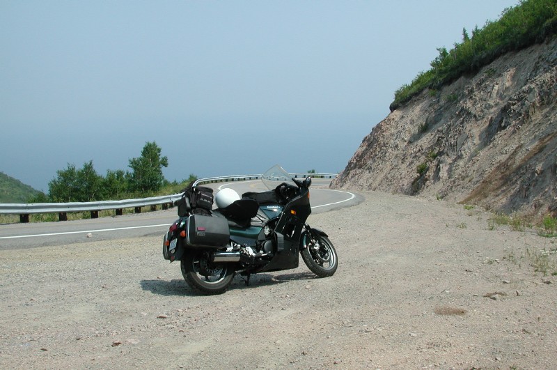 South I go, out of the park, and past Ingoish. There I climb
a mountain called Smokey. I stop, looking out over the Atlantic. I
rest in the shade, adjust the map, and put on more sun block (See. I can
learn). The bike is happy, in it's natural environment.
Mostly. For instance, here it is on a packed gravel shoulder,
pointing downhill. I almost dropped it trying to get it ready to go, when
gravel rolled out from under my foot. Oy vey. I recovered, though,
and off we went.
South I go, out of the park, and past Ingoish. There I climb
a mountain called Smokey. I stop, looking out over the Atlantic. I
rest in the shade, adjust the map, and put on more sun block (See. I can
learn). The bike is happy, in it's natural environment.
Mostly. For instance, here it is on a packed gravel shoulder,
pointing downhill. I almost dropped it trying to get it ready to go, when
gravel rolled out from under my foot. Oy vey. I recovered, though,
and off we went.
Baking again, I stop in South Gut of St Anne for ice cream and water. I help an older couple find themselves on the map. I take off again, heading south on 105. It's just too hot and exhausting for me to take any other route. At about 4:00, I get stopped at another of N.S.'s construction sites. 10 minutes in the sun, before we get to go. Phew.
At 4:45, I'm at the roundabout in Port Hawkesbury, sitting, waiting, with a whole lot of others, as the bridge opens to let a ship through the channel. While waiting, a car on the causeway boils over. It's 5:10 before I make it to the Irving gas station on the other side.
Gas up the bike, and I drink water. I feel disconnected, and I'm panting. I stand in the shade, and then go inside the slightly air conditioned gas bar until I feel a little better. And then it's time for today's stupidest decision. I bundle up my jacket, and set off for Antigonish. It's so hot, I just couldn't face putting it on. In a few kilometers, it's obvious that:
It's cooler with the jacket.
It's so hot every bit of sweat is sucked away by the wind immediately.
This was a dumb idea.
I make it to Antigonish, and stop at the Comfort Inn. Then I stand over the a.c. for 10 minutes or so. I drink some water, and lay on the bed. Yeah, it's only 6:00, but I'm done for the day. I lie on the bed, and wake up about 6:30. The good news is, I'm sweating again. After a shower, I get to work on pictures and web stuff. The connection here is 22Kb - better, but again, no new big pictures.
So, 503km today in some great roads and scenery. It's darned hot, so I think I'll get up earlier tomorrow, and try to make time while the sun is low in the east. Don't want another incident like today's. I had two other death cheat's, to do with passing on two-lane blacktop. But the de-hydration is very scary. The Weather Network is betting on rain in N.B. tomorrow. At least it'll be cool.